-
TELEDFO
-
VISTACTO Proyect
-
Early Detection of Crises in Autism Project (PETRA)
-
Easier Project
-
TalkAACtive Project
-
DaVOZ Project
-
Sicse Project
-
SmartLazarus Project
-
Graces
-
Light Access Logistics
-
Contacto
-
Smile @work
-
Audismart
-
Comillas
-
CicerOn
-
CrossCursor
-
Observatorio de Accesibilidad
-
AMICOG
-
IntegraGame
-
REM
-
e-Glance
-
ElCano
-
POSET
-
APR
-
INLADIS
-
SAINET
-
I'M NEW HERE
-
ARGOS
-
MOVI-MAS
-
MOVI-CLOUD
-
UIKA
-
DIUWA
-
Receptor Accesible
-
Virtual Coach
-
Emplea-T Accesible
-
Ganas
-
Indensound
-
VirtualKeyboard
-
SOCIAL MENTORING
-
ALMA
-
LightAccess
-
Ilumno
-
PROLOG
-
HEADMOUSE
- País:
- Universidad:
-
Tipo de discapacidad:
Motriz
- Año:
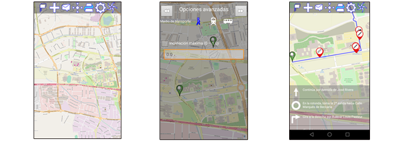
Developed by the University of Málaga, the project consists of an application for Android devices that provides people with reduced mobility real-time information about the best routes to following between a given point of origin and destination, steering them toward adapted areas and helping them avoid crowds and places where building works are in progress.
The system can also channel to the relevant public authorities any requests for infrastructure improvements that users consider necessary to ensure their inclusion, such as the replacement of steps with ramps and the creation of wider sidewalks.
Another feature of this application is the use of augmented reality in the guiding system and to provide information on accessible points, and the use of GPS and other complementary technologies to locate the user's position/orientation. It will also process information about the user's routines automatically and intelligently, which will help the system to identify significant situations or milestones and then factor the conclusions into the service.
Phase 2 of the ALMA project entailed the optimisation and expansion of the benefits and services provided by the ALMA platform in Phase 1.
The main improvements included in this second phase are:
- Optimisation of the engine for calculating routes to be capable of managing maps of different sizes efficiently.
- Implementation of an algorithm for automatically calculating gradients. The information obtained could be useful for calculating routes.
- Possibility of making multi-modal routes. Inclusion of buses and underground rail as accessible means of transport in addition to the walking routes already available in phase 1 of the project.
- Lastly, the ALMA platform was integrated with Sofia2. Doing so, the information on obstacles compiled by users would be available not only for users of the ALMA platform but also by anyone else who wanted to make use of it.
Related links